6th Armored Division Campaign Map
NOTE: As of November 17, 2012, a small number of full-size, high-resolution reprints of this map are available on eBay at https://www.ebay.com/itm/300815324839
Supplement: Color Map, Campaigns of the Super Sixth Armored Division
[Web editor's notes: This large (roughly 15" x 36") map was distributed in a pocket on the back cover of the Combat Record of the Sixth Armored Division in the E.T.O. 1944 - 1945. It was also folded and attached to the back cover of the History of the 212th AFA Battalion, and was included in one or two other unit histories.
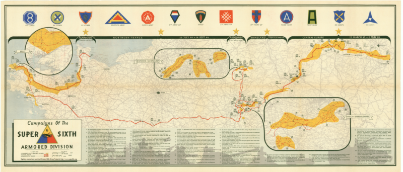
The top of the map shows the DI ("distinctive insignia") of the various commnds to which the Division was assigned during its time in Europe.
The five battle stars along the top of the map represent the campaigns
in which the 6th Armored participated:
Normandy, Northern France, Ardennes, Rhineland, and Central Europe.
The map presented here was rescanned in October 2008 and uploaded to the site on December 29, 2008. The original version that was here from 1995 had been scanned at lower resolution and was done in segments. The entire top of the map was cropped due to the size of the equipment used originally, and the original (taken from the 212th AFA history) was in poorer shape than the original used for the current scan (from the Combat Record of the Sixth Armored Division.)
Large version (~2 MB)
The text along the bottom of the map is reproduced below.
The numbers labeling the text along the bottom of the map correspond to index numbers on the body of the map. The route starts under the left-most gold
star, with the Division coming ashore at Utah Beach a few weeks after D-Day [1,2].
They then fight to the west toward Brest [3 - 8, with left-most inset], then race
eastward over the course of just a few days [9 - 11]. The drive then comes to a
screeching halt, thanks in part to Montgomery's siphoning of resources to support
his disastrous Market Garden offensive. The 6th, along with the rest of the Third Army,
spends nearly three months fighting around Luneville, Armacourt, the Saar, and the
Seille and Maderbach Rivers [12 - 24, with right-most inset].
Patton's famous swing to the north to the Battle of the Bulge is clearly
visible near the center of the map [25 - 42, with center inset]. The final thrust
into Germany ends at the right [43 - 60], far into what will later become East Germany.
(Patton had to pull his Army back to approximately the position of the rightmost
star, where the East/West German border would come to be located
as we settled things with our "loyal Soviet allies".)]
Links:
 6th Armored Division Assoc. Home Page.
212th Field Artillery Home Page.
Table of Contents, History of the 212th FA
Visit the black and white version of this map in the 212th History.
Information about the 212th FA and 6th Armored Division veterans' associations.
Links to related sites.
NOTE: Remove question mark from address below when sending email
This page is maintained by Bruce Frederick, EMAIL .
Last updated: December 29, 2008. New map scan.


